
Virginia's Rivers (Part 1)
Introduction
• Virginia is served by 9 major river systems: Potomac-Shenandoah, Rappahannock, York, James, Roanoke, Chowan, New, Tennessee, and Big Sandy.
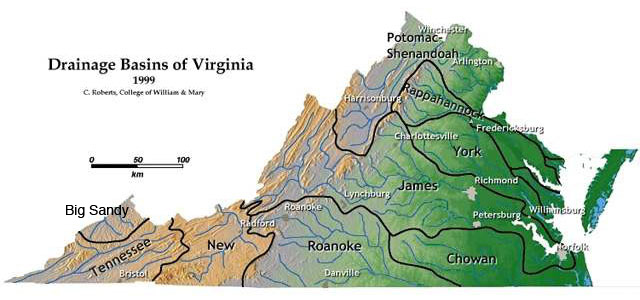
Map shows the 9 major drainage basins of Virginia. (Image from the College of William & Mary geology website, courtesy of C.M. Bailey)
• The area of land that collects the surface water that flows into the major river is called a drainage basin or watershed. This includes all parts of the river, and all of its tributaries.
• A drainage divide is the line of high ground that separates adjacent drainage basins. On the map above, they are the heavy black lines. Water flows downhill away from a drainage divide toward the major river of the basin.
• In Virginia, the continental divide separates the New River from the Roanoake and James River. East of the continental divide, the rivers flow east or south toward the Atlantic Ocean. West of the continental divide, the rivers flow north or west toward the Gulf of Mexico by way of the Ohio and the Mississippi Rivers.
• The rivers that flow toward the Atlantic are: Potomac-Shenandoah, Rappahannock, York, James and Chowan.
• The rivers that flow toward the Gulf of Mexico are: New, Tennessee, and Big Sandy.
• Many large cities and prominent towns are located along Virginia rivers, especially along the Fall Line. Major Fall Line cities include: Washington D.C. (Potomac), Fredericksburg (Rappahannock), Richmond (James), Petersburg (Appomattox), Emporia (Meherrin), and in North Carolina, Roanoke Rapids (Roanoke River). These cities are connected by Interstate-95.
Chesapeake Bay Rivers
• Virginia has 4 major river systems that flow into the Chesapeake Bay and then toward the Atlantic Ocean. They are, from north to south: the Potomac-Shenandoah River system, the Rappahannock River, the York River, and the James River.
• The 4 rivers create three penninsulas or "necks" in the Coastal Plain: the Northern Neck, the Middle Neck, and the Virginia Penninsula (or Southern Neck) which includes Williamsburg and the Hampton Roads area.
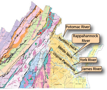 The three penninsulas or "necks" of the Coastal Plain. (Map courtesy of the Virginia Division of Geology and Mineral Resources)
• The entire Chesapeake Bay watershed also includes the Susquehanna River of Pennsylvania. The 5 rivers create a large watershed area that covers parts of Virginia, Maryland, West Virginia, Pennsylvania, Delaware, New York, and all of Washington D.C. The watershed contains over 64,000 square miles and is home to over 17 million people.
• The combination of densly populated cities with agricultural areas creates concern for the cleanliness of the water in the bay. For more information, click here.