
Virginia's Rivers (Part 2)
Potomac-Shenandoah River System
• The Potomac River's watershed area includes parts of Virginia, West Virginia, Maryland, and Pennsylvania.
• Flows from the Valley and Ridge to the Blue Ridge, then Piedmont, and the Coastal Plain where it reaches the Chesapeake Bay.
• Over much of its course, it forms the southwestern state boundary of Maryland where it borders West Virginia and Virginia.
• In Fairfax County, it forms spectacular waterfalls at Great Falls. Here, the river is eroding resistant metamorphic rocks of the Piedmont at the Fall Zone.
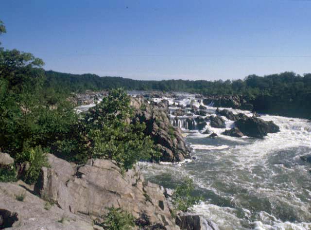
Great Falls Park, Fairfax County. (Photograph by Robert Whisonant)
• The Potomac's major Virginia tributary is the Shenandoah River. The confluence of the two rivers is at Harpers Ferry, where the Potomac flows through a water gap through the Blue Ridge. The Shenandoah joins the Potomac just west (upstream) from the water gap.
Google terrain view of the confluence of the Shenandoah River with the Potomac River at Harpers Ferry which is at the tri-state border of Virginia, Maryland, and West Virginia. The rivers join at the Potomac Water Gap where they flow across the Blue Ridge (western ridge) and South Mountain (eastern ridge). Here the rivers have eroded through hard, resistant, Cambrian quartzite. The Valley and Ridge-Blue Ridge province boundary is where the rivers join. Select Earth view to get a 3D image of the land. (Map data by Google)
View Larger Map
Google Street View image from the U.S. 340 bridge over the Potomac looking westward toward the Potomac Water Gap. If one pans the image to look east, the South Mountain water gap can be seen. (Map data by Google)
• In Virginia, the Shenandoah River flows along the "Great Valley". At Front Royal, two main forks of the river merge. The North Fork flows on the northwest side of Massanutten Mountain where it parallels I-81. The South Fork flows on the southeast side of Massanutten Mountain.
Google terrain view of the confluence of the North and South Forks of the Shenandoah River near Massanutten Mountain (southwest corner of the map) at Front Royal. (Map data by Google)
 View of the meander loops of the Shenandoah River. (Image courtesy of the Virginia Division of Geology and Mineral Resources)
