
Valley and Ridge Physiography: Drainage (Part 1)
• The Valley and Ridge is drained by five major stream systems -- the Potomac-Shenandoah, James, Roanoke, New, and Tennessee.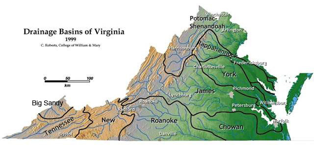
Map of Virginia’s major drainage basins. Note that the Potomac-Shenandoah, James, and Roanoke Rivers all flow eastward into the Atlantic Ocean, whereas the New and Tennessee systems are part of the Gulf of Mexico drainage area.
(Image from College of William & Mary geology website, courtesy of C.M. Bailey)
• Valley and Ridge streams form a trellis drainage pattern in many places. In such areas, the main stream flows parallel to the valleys and ridges. Short tributaries join the main stream at nearly right angles to form the garden trellis pattern.
 In the Valley and Ridge, streams flow nearly parallel to the mountains. Long straight streams follow the less resistant rocks in valleys (the local roads run parallel to streams), while small tributary streams flow off the ridges in to the main streams at nearly right angles. This is called a trellis drainage pattern because its shape resembles a garden trellis. The area shown is northwest of Salem, Virginia, in the Jefferson National Forest, showing parts of Roanoke, Craig, and Montgomery Counties. (Map data: Google)