|
|
||||||||
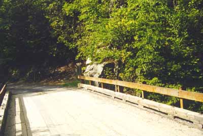 The place to check is the white rock that is on the north end of the bridge just past where the vehicles are parked (you can see the outcrop in the photo to the left, practically in the center of the picture) The place to check is the white rock that is on the north end of the bridge just past where the vehicles are parked (you can see the outcrop in the photo to the left, practically in the center of the picture) |
||||||||
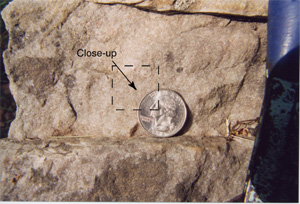 What type of rock is this (look at the closeup photo below...note the light color and the visible grains)?. What is the main mineral in this? (Hint: note how very hard this rock is.) What was the depositional environment? (Hint, Hint: think summertime!) Note how uniform the rock is in terms of its grain size and mineralogy. Under a handlens, the grains are translucent and rounded. Answer What type of rock is this (look at the closeup photo below...note the light color and the visible grains)?. What is the main mineral in this? (Hint: note how very hard this rock is.) What was the depositional environment? (Hint, Hint: think summertime!) Note how uniform the rock is in terms of its grain size and mineralogy. Under a handlens, the grains are translucent and rounded. Answer |
||||||||
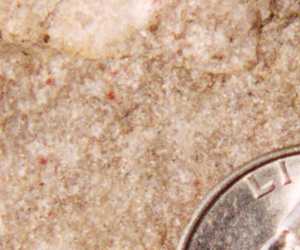 Close up of the outcrop at the end of the bridge. Close up of the outcrop at the end of the bridge.
|
||||||||
|
|
||||||||
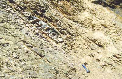 If you have the time, walk down the trail to spot 14. The rocks will become distinctly shaly and muddy. What might this represent? Note: it is also possible to see the same rocks in the outcrops along Rt. 859 as you drive to the next stop . As the road climbs out of the Green Cove Creek area, look for little cut-out areas on the right side of the road where the rocks are thinner bedded (the photo on the left is from a small quarry along the road). Answer If you have the time, walk down the trail to spot 14. The rocks will become distinctly shaly and muddy. What might this represent? Note: it is also possible to see the same rocks in the outcrops along Rt. 859 as you drive to the next stop . As the road climbs out of the Green Cove Creek area, look for little cut-out areas on the right side of the road where the rocks are thinner bedded (the photo on the left is from a small quarry along the road). Answer
|
||||||||
 |
||||||||