|
|
|
|
|
|
|
 |
|
 |
|
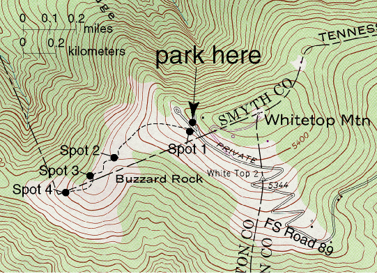
| Taken from the WHITETOP MOUNTAIN, VA, 1:24,000 quadrangle, 1959, Rev. 1978 |
|
|
|
|
|
| Directions: Forest Service Road 89 is a gravel road that is normally kept in good repair. However, it does have its rough spots especially in the area near the top, where the trees give way to open spaces, and the road switchbacks. A regular passenger car should do OK on this road, but it will not exactly be smooth. Near the top, the road will divide and will go into a loop. Take the right fork and park in the small gravel parking area on the left. |
|
|
|
 |
|
|
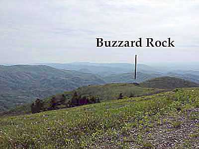
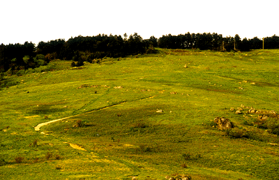
View from the trail head looking southwest toward Buzzard Rock.
|
|
|
|
Step out of your vehicle and look around. If you have any kind of decent weather, your reaction to the view will be: "WOW!!!!" On a clear day, you can easily see as far as 40 miles. As spectacular as the scenery is, the view will be better from Buzzard Rock which you can see as a craggy rock sticking out of the right side of the topographic nose to the southwest. We are approximately one mile high in elevation. If you have been paying attention on the ride up, we are above the elevation where hardwood trees thrive and conifers are the main type of tree. Even then, vegetation is stunted and assaulted by the harsh winds.
If you look out toward Buzzard Rock, you can see the trail that leads out there - that is the famous Appalachian Trail (or "A.T."). Just below the parking area is the entrance to the trail.
|
|
| Stop preview: There is some hiking involved at this stop. Although the distance is not very far (less than a kilometer to the furthest spot), the return to the parking area is uphill, and with the thinner air, people who are not exactly in top shape will huff and puff. This is should not be a problem if you simply walk slowly. See the box below on weather here. Another cautionary note: the reason why Whitetop Mountain is so high is because the rocks here are quite hard. Be cautious when hammering the rocks. |
|
|
|
|
|
 |
|
|
|
A Word on Whitetop Mountain Weather...
|
|
|
|
|
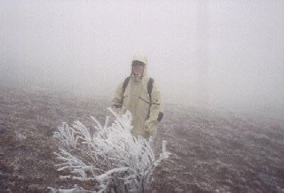 The weather on Whitetop Mountain is unpredictable and may not bear much relationship to the weather in the surrounding area. Always be prepared for much colder temperatures and windier conditions. As a rule of thumb, dress for temperatures 20° colder than that of the surrounding area. Between the months of November to March, ice and sub-zero wind chill conditions may exist and anybody up here must guard against hypothermia. The picture on the left was taken in late March. It was so cold that icicles formed on our hats, gloves, glasses, mustaches, etc. Thick blinding fog is also common and sudden thunderstorms and hail may accost you during the warmer months (we also have stories of hair standing on end while dark clouds formed above us). If reasonable visibility is not present then it is easy to lose your way off the trail. Do not attempt this field trip stop unless the conditions are clear and dry and you are properly dressed. The weather on Whitetop Mountain is unpredictable and may not bear much relationship to the weather in the surrounding area. Always be prepared for much colder temperatures and windier conditions. As a rule of thumb, dress for temperatures 20° colder than that of the surrounding area. Between the months of November to March, ice and sub-zero wind chill conditions may exist and anybody up here must guard against hypothermia. The picture on the left was taken in late March. It was so cold that icicles formed on our hats, gloves, glasses, mustaches, etc. Thick blinding fog is also common and sudden thunderstorms and hail may accost you during the warmer months (we also have stories of hair standing on end while dark clouds formed above us). If reasonable visibility is not present then it is easy to lose your way off the trail. Do not attempt this field trip stop unless the conditions are clear and dry and you are properly dressed. |
|
|
|
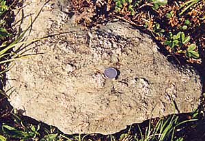
| Geology preview: As you walk along the trail toward Buzzard Rock, you will travel from younger to older rock. Stop first at the scattered outcrops around the trail entrance near the road. Here and there some faint banding from lava flow layering is evident. The rock type is rhyolite of the upper Mount Rogers Formation. This part of the Mount Rogers has been subdivided into three parts or "members": the Buzzard Rock member (lowest), the Whitetop Mountain member (middle), and Wilburn Ridge member (upper). The three members may be distinguished in outcrop by their textures. The Buzzard Rock has visible phenocrysts of pink potassium feldspar and light gray plagioclase. The Whitetop Mountain has very few phenocrysts (and if you see them, they are potassium feldspar and quartz), and the Wiburn Ridge (which is not exposed here) is phenocryst rich (potasium feldspar and quartz). |
|
|
|
|
Check the rocks along the trail. We will ask you to stop at certain places to observe and test your knowledge by answering some questions. Click on the "answer" link for explanations and for more information.
|
|
SPOT 1: At the entrance to the trail
|
|
|
|
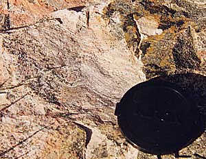 Look at a few of the outcrops at the trail entrance to get a feel for the main rocks here. Unfortunately, lichen obscures many of the textures, so you will have to look closely. Do you see many phenocrysts? Based on this, which of the three members is exposed here? Undoubtably, you have noticed how hard the rocks are. Reviewing your knowledge of igneous rocks, what minerals are in a rhyolite? (Hint: the grain size is fine, so it is difficult to see the minerals with the unaided eye, but note the light overall color of the rock.) What is it that makes the rocks so hard? A common conception people have about both Whitetop Mountain and Mount Rogers is that the mountains themselves are extinct volcanoes. Is this true? Here and there in the loose rock you can find some fine grained green rocks. These rocks are also igneous. What kind of rocks are these? Answers Look at a few of the outcrops at the trail entrance to get a feel for the main rocks here. Unfortunately, lichen obscures many of the textures, so you will have to look closely. Do you see many phenocrysts? Based on this, which of the three members is exposed here? Undoubtably, you have noticed how hard the rocks are. Reviewing your knowledge of igneous rocks, what minerals are in a rhyolite? (Hint: the grain size is fine, so it is difficult to see the minerals with the unaided eye, but note the light overall color of the rock.) What is it that makes the rocks so hard? A common conception people have about both Whitetop Mountain and Mount Rogers is that the mountains themselves are extinct volcanoes. Is this true? Here and there in the loose rock you can find some fine grained green rocks. These rocks are also igneous. What kind of rocks are these? Answers |
|
|
|
SPOT 2: Ledges along the trail to Buzzard Rock
|
|
|
|
| Next, head down the trail toward Buzzard Rock. At about 2/3 of the way to Buzzard Rock, note the ledges of rock that cut obliquely across the trail. |
|
 The view back up the trail from Buzzard Rock. In the center of the picture, note the line of rocks that cross the trail. This is the ledge of rock to look for at spot 2. The view back up the trail from Buzzard Rock. In the center of the picture, note the line of rocks that cross the trail. This is the ledge of rock to look for at spot 2. |
|
 Look closely and see if you can find various internal objects of differing material. Some of the objects look rounded and vaguely pebble-like, others look angular. How might this have formed? Answer Look closely and see if you can find various internal objects of differing material. Some of the objects look rounded and vaguely pebble-like, others look angular. How might this have formed? Answer |
|
|
|
| Next, walk out to Buzzard Rock. Before looking at the rocks themselves, check out the view! Turn around and see if you can see back to where you parked. Isn't it amazing amazing how close Buzzard Rock seemed from the parking area, but now how far the parking area seems from Buzzard Rock? |
|
|
|
|
|
 |
|
 |
 |
|
 |
 |
 |
|
|
|
|
|
|
|
|
|
|
|
|
|
|
|