| Province:Blue Ridge
Grayson, Washington, and Smyth Counties The Mount Rogers Formation extends in a belt that extends from near the tri-state boundary of VA, TN, and NC approximately 30 km to the northeast into Grayson County. It contains a unique set of rocks that is 30% sedimentary and 70% volcanic. The volcanic rock is unusual in Virginia in that it is composed of thick rhyolite (along with basalt), forming a hard resistant rock that holds up the highest peak in Virginia - Mount Rogers is 5729 feet above sea level. The stratigraphy of the Mount Rogers Formation has been recently redefined by Rankin (1993). The glacial units that were formerly considered to be in the upper part of the Mount Rogers Formation have been placed in their own unit, the Konnarock Formation. Complicating the stratigraphy of this formation is the fact that thrust faults chop the formation into several thrust sheets and rocks of one thrust sheet are not always found on other thrust sheets. The Mount Rogers Formation nonconformably rests on top of the Cranberry Gneiss and is approximately 3000 meters in total thickness. |
|||||||||||||||||||||||
| Lower part of the Mount Rogers Formation
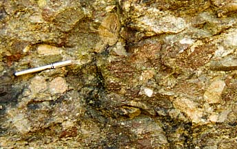
The lower part of the Mount Rogers Formation is dominated by sedimentary rocks. Conglomerate is common in this part of the formation. It is typically clast-supported with pebbles derived from both the erosion of volcanic units (both rhyolite and basalt) within the lower Mount Rogers and from erosion of the Cranberry Gneiss. Other sedimentary rocks in the lower part are sheared sandstone, and deformed shale. Rhyolite can also be found, and Rankin (1993) has subdivided the volcanic rocks into three volcanic centers (the Fees, Pond Mountain, and Razor Ridge) depending on which thrust sheet they are found. Rankin describes the Fees Rhyolite as containing approximately 35% phenocrysts composed of quartz, perthite, and plagioclase, with the presence of both plagioclase and quartz phenocrysts distinguishing these rhyolites from the younger main Mount Rogers rhyolites. |
|
||||||||||||||||||||||
|
|||||||||||||||||||||||
| Upper part of the Mount Rogers Formation
The upper Mount Rogers Formation is prominent at Whitetop Mountain (Mt Rogers Field Trip, stop 5), and also spectacularly exposed in Grayson Highlands State Park as described at Stop 14 in Rankin and others (1994). The dominant rock type is rhyolite along with various pyroclastic rocks such as felsic tuffs and breccias. Formerly, the volcanic rocks were divided into three units: the "A" (upper), "B" (middle), and "C" (lower). Rankin (1993) has renamed the lower unit the "Buzzard Rock Member", the middle unit the "Whitetop Rhyolite Member", and the upper unit the "Wilburn Rhyolite Member. These rocks are all part of the Mount Rogers volcanic center. |
|||||||||||||||||||||||
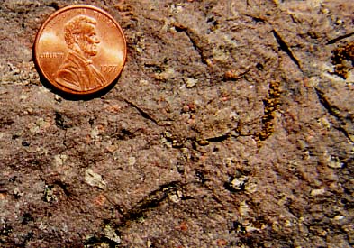
| Buzzard Rock Member: The Buzzard Rock Member (300 meters thick) is composed of a maroon or purple-gray aphanitic rock with phenocrysts of perthitic alkali feldspar and plagioclase. Typically, the phenocrysts make up 5 to 20% of the rock. Light-dark color banding representing flow layering indicates that these were lava flows. |
|
||||||||||||||||||||||
|
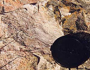
Whitetop Rhyolite Member: The Whitetop Rhyolite Member (500 meters thick) is an aphanitic gray-purple rock that is phenocryst poor (0-10%). The few phenocrysts that are present are quartz and perthite. Mostly, the Whitetop Rhyolite is massive and bears few distinguishing marks. Occasional flow layering indicates that substantially, this unit was a series of lava flows. However, in a few places, pyroclastic rocks may be observed, most notably at the base of the Whitetop Rhyolite where it is in contact with the Buzzard Rock Member on Whitetop Mountain. There, a tuff breccia contains clasts of Buzzard Rock, Whitetop Rhyolite, and even the underlying Cranberry Gneiss. |
|
||||||||||||||||||||||
| Wilburn Rhyolite Member: The Wilburn Rhyolite Member (750 meters thick) is a grayish purple aphanitic rock with phenocrysts of perthite and quartz making 30% of the rock. This unit is interpreted to have formed as an ash-flow tuff. Evidence supporting this are numerous fiamme (flattened pumice lumps). At the base of the Wilburn, at the contact with the Whitetop Rhyolite, there are prominent lithic inclusions consisting of pieces of Whitetop Rhyolite, Buzzard Rock Member, and even pieces of granitic basement. These inclusions may be a combination of pieces of the walls of the vent that were ejected during eruption, and pieces of the ground surface over which the ash flow moved.
Recent isotopic work on the age of the Mount Rogers Formation has yielded an age of 760 million years (Aleinikoff and others, 1991). This age is quite significant in terms of the tectonic implications and the timing of the opening of the Iapetus Ocean (see the geologic history page of the Mount Rogers trip). |
|||||||||||||||||||||||
| Links for additional information:
Mount Rogers Field Trip Stop 5 Mount Rogers Field Trip Stop 1 |
|||||||||||||||||||||||
| References:
Aleinikoff, J.N., Zartman, R.E., Rankin, D.W., Lyttle, P.T., Burton, W.C. and McDowell, R.C., 1991, New U-Pb zircon ages for rhyolite of the Catoctin and Mount Rogers formations: more evidence for two pulses of Iapetus rifting in the central and southern Appalachians: Geological Society of America, Abstracts with Programs, v. 23, no. 1, p. 2. Rankin, D.W., 1967, Guide to the Geology of the Mt. Rogers area, Virginia, North Carolina and Tennessee: Carolina Geological Society Field Trip Guidebook. Rankin, D.W., 1993, The volcanogenic Mount Rogers formation and the overlying glaciogenic Konnarock Formation - Two Late Proterozoic units in southwestern Virginia: U.S. Geological Society Bulletin 2029, 26 p. Rankin, D.W., Miller, J.M.G., Simpson, E.L., 1994, Geology of the Mt. Rogers area, southwestern Virginia Blue Ridge and Unaka Belt: in Schultz, A., and Henika, B. (editors), Fieldguides to southern Appalachian structure, stratigraphy, and engineering geology: Virginia Tech Guidebook No. 10, p. 127-176. |
|||||||||||||||||||||||
|
|
|||||||||||||||||||||||


