![]()
|
|
|
|

Satellite: NOAA-15
Taken yesterday:
August 4, 2004; flyover beginning 6:05pm EDT
These images show
Hurricane Alex taken from the vantage point of NOAA's
850km-high (530 mile-high) Polar
Orbiting satellites.
Looking straight down the eye of the storm:
Hurricane Alex southeast of Cape Cod (Massachesetts).
At its widest, the eye of the hurricane is about 45 kilometers across.
Since this was taken in the evening, it is difficult but still possible to see
down to the ocean's surface in the calm eye.
The thermal image at the bottom of the page, taken in infrared light, clearly
reveals the warmer ocean surface within the eye.
Click on the image below for a higher-resolution image (over 100k).

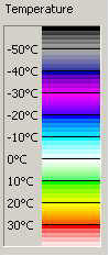
Thermal image of the same picture as above;
temperature scale at right.
The warm ocean surface is uncovered at the center of the eye and is a balmy 200C
or more.