LESSON 2
Investigation: Geology of Virginia
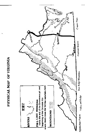
Introduction: The State of Virginia is comprised of five different geologic provinces. They include the Appalachian Plateau, Valley and Ridge, Blue Ridge, Piedmont, and Coastal Plain. Each province is characterized by having different age and type of rocks exposed at the surface. In this investigation, you will identify the location, age, and rock type found in each province. In addition, you will examine rock specimens from each area and research their origin.
Materials: Geologic Map of Virginia, rock samples of Virginia, colored pencils
Procedure:
1. Examine the colorful geological map of Virginia. Color code the Physical Map located in the lab packet for each province. Color code the key for the provinces and not rock type, era, periods, or age. Each province should be a different color.
2. Complete the first two columns of the lab analysis table using the information listed on the geological map.
3. Examine the rock types found in the classroom from each of the five provinces. Write a description in the space provided in the table and research the origin using the spiral geology books or the textbooks. You may find more than one rock from each province.
4. Answer the questions in the Analysis section using the map and any reference books available.
Analysis
1. Where is the youngest rock/sediment in Virginia located? List the age (era, period, composition) and province. Why do you think this hasn’t become rock yet?
2. Where is the oldest rock located? List the age and province.
3. What rock type is found in Arlington? List age and province.
4. Where in Virginia are coal deposits found? List ages and provinces. What type of environment existed here during the late Paleozoic?
5. In what part of the state are you likely to find fossils of ancient marine animals preserved in rock? _______________________________ Why?
6. The rocks in the valleys of the Valley and Ridge Province are mostly limestone, whereas the ridges (mountains) consist of sandstone. Explain why? (You can look in your notes when we studied limestone and its characteristics).
7. How does the composition of the Blue Ridge Mountains differ from the ridges in the Valley and Ridge Province?
8. Read the following question and examine the map of Virginia, then choose the correct answer.
"Most of the rocks on the map seem to line up in the same direction."
The direction is mostly
a. North to south
b. East to west
c. Northeast to Southwest
9. The term "Piedmont" appears to first have applied to an actual area in what is now northwestern Italy. In its literal sense, it means "near the foot of a mountain". Do you think the region identified as the Piedmont in Virginia is appropriately named? Why or why not?
10. Between what geological provinces is the Fall Line located? Where can it be seen easily in Northern Virginia?
11. Interspersed among the Piedmont Geologic Province are the Triassic Basins of red rocks (sandstone and shales), where dinosaur footprints have been found. How did these basins form?
Conclusion: Write a brief geologic history of Virginia using your own paper. You may use your notes, geologic map, or any reference book.
Refer to your Geologic Map of Virginia and rock samples to obtain the requested information below.
|
Province |
Era
|
Period
|
Age
|
Rock Types
|
Place of Origin
|
Describe the rocks
|
|
Coastal Plain
|
|
|
|
|
|
|
|
Piedmont |
|
|
|
|
|
|
|
Blue Ridge Mountains |
|
|
|
|
|
|
|
Valley & Ridge |
|
|
|
|
|
|
|
Appalachian Plateau |
|
|
|
|
|
|
Back to Partipant Resource Page
![]()