| PROVINCE: BLUE RIDGE
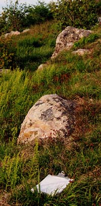
Carroll and Grayson Counties The Cranberry Gneiss, named after exposures at Cranberry, North Carolina, represents the approximately one-billion-year-old continental basement that is part of the Grenville Province of rocks that is found along the eastern seaboard of North America. Plutonic rocks of this age in the southwest Virginia Blue Ridge are considered to be part of the "Elk Park Plutonic Group". Their northwesternmost extent is exposed near Sylvatus, VA and they extend southwestward into North Carolina. It underlies much of the northwestern part of Grayson County where it forms a rolling landscape with spheroidally weathered gray outcrops. |
|||||||||||||
|
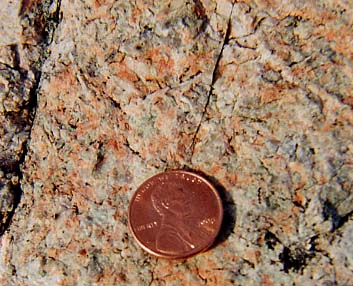
The Cranberry Gneiss is typically composed of a granite to diorite suite of rocks, with microcline, plagioclase, quartz, and biotite and/or hornblende. It is thought that much of the Cranberry Gneiss was originally plutonic in origin, and where it is not sheared, is typically a phaneritic, coarse-grained rock. Paleozoic shearing is very common in the Cranberry, causing stretching of the feldspar and quartz into augens. Thin bands of metamorphic muscovite are common, giving the rock a layered appearance. The Cranberry Gneiss has not been mapped in detail, but Bartholomew and Lewis (1984) report considerable heterogeneity, with parts of the Cranberry being possibly sedimentary in origin, perhaps serving as older country rock into which the igneous "Cranberry" had intruded. Thus, the Cranberry story appears to be quite complex and further mapping is necessary. On the Mount Rogers trip, we will encounter the Cranberry in two settings: as part of the regional bedrock where it looks sheared and layered, and as sedimentary clasts in both the Mount Rogers Formation and in the diamictite of the Konnarock Formation. It is interesting to note that as sediment in Proterozoic rocks which predate the Paleozoic deformation, the sedimentary clasts of Cranberry do not show the same banding and shearing that are present in the surrounding country rock.
|
|||||||||||||
|
|||||||||||||
|
|||||||||||||
| Links for additional information:
Mount Rogers Field Trip, stop 5 |
|||||||||||||
| References:
Bartholomew, M.J. and Lewis, S.E., 1984, Evolution of Grenville massifs in the Blue Ridge geologic province, southern and central Appalachians: in Bartholomew, M.J., (editor), The Grenville Event in the Appalachians and Related Topics: Geological Society of America, Special Paper 194, p. 229-254. Rankin, D.W., 1967, Guide to the Geology of the Mt. Rogers area, Virginia, North Carolina and Tennessee: Carolina Geological Society Field Trip Guidebook. Rankin, D.W., 1993, The volcanogenic Mount Rogers formation and the overlying glaciogenic Konnarock Formation - Two Late Proterozoic units in southwestern Virginia: U.S. Geological Society Bulletin 2029, 26 p. Rankin, D.W., Espenshade, G.H. and Neuman, R.B., 1972, Geologic map of the west half of the Winston-Salem Quadrangle, North Carolina-Virginia-Tennessee: U.S. Geological Survey, Miscellaneous Investigations Series, Map I-709A. Rankin, D.W., Espenshade, G.H., and Shaw, K.W., 1973, Stratigraphy and structure of the metamorphic belt in northwestern North Carolina and southwestern Virginia: A study from the Blue Ridge across the Brevard Fault Zones to the Sauratown Mountains Anticlinorium: American Journal of Science, v.273-A, p. 1-40. Rankin, D.W., Miller, J.M.G., Simpson, E.L., 1994, Geology of the Mt. Rogers area, southwestern Virginia Blue Ridge and Unaka Belt: in Schultz, A., and Henika, B. (editors), Fieldguides to southern Appalachian structure, stratigraphy, and engineering geology: Virginia Tech Guidebook No. 10, p. 127-176. |
|||||||||||||
|
|
|||||||||||||
| Mount Rogers Field Trip | |||||||||||||