|
|
|
|
|
 |
|
SPOT 1
|
|
|
|
| Most of the rocks here are light gray and fairly featureless with few phenocrysts seen. Thus the rock exposed is of the Whitetop Mountain member of the Mount Rogers Formation. Rhyolite is a fine grained rock composed of potassium feldspar, quartz and plagioclase, with maybe a little biotite. The tight, non-porous texture along with the quartz, which is quite resistant to erosion and makes the rock very hard, causes a large area of rhyolite like this one to erode down much more slowly than the surrounding rock, thus forming a mountain. Both Mount Rogers and Whitetop Mountain were parts of a much larger rhyolite mass which has since been cut into by recent erosion. Thus, the mountains themselves were not individual volcanoes but are merely erosional remnants of a larger lava pile. Keep in mind that the age of the rocks are 760 million years and none of the original landforms have survived from that time. The green rocks are bits of basaltic dike material that cut through the rhyolite. The combination of felsic and mafic rocks without any intermediate rocks was noticed at stop 4. |
|
|
|
|
|
|
|
|
SPOT 2
|
|
|
|
| We are now near the boundary between the Buzzard Rock member and the Whitetop Mountain member, just into the base of the Whitetop member. Apparently, there was a pause between the eruption of the Buzzard Rock and the Whitetop. During this pause, the top of the Buzzard Rock was a land surface which was subjected to erosion and stream deposition, accounting for some of the rounded pieces. During the initial phases of the eruption of the next layer of lava (the Whiteop in this case), the eruptions were quite explosive and there was some airborn material (tuffs and angular volcanic clasts of various material) which were then deposited on the land as rubble. This might account for the various different sizes, shapes and types of material found here. |
|
|
|
|
|
|
|
|
SPOT 3
|
|
|
|
| Toward the northwest, the view is into the Valley and Ridge geologic province. This is composed of tilted and thrust faulted sedimentary rocks. Most of the ridges are made of resistant sandstone - vast sheets of durable rock tilted up on their edges to create the long ridges. The foreground ridges are of the Unicoi and Erwin Formations (Straight Mountain first, then Grosses Mountain behind), both sandstones. Beyond that is a thick expanse of non-resistant rock making up the broad valley (the Holston River is contained in this area). Much of this is Cambrian and Ordovician carbonates of the Great Valley along which runs I-81. Beyond that are sandstone ridges of various Silurian and Mississippian formations (Flattop and Clinch Mountains). We say that the rocks "strike to the northeast" because the ridge and valley structure runs northeast-southwest. Toward the southeast, however, the view is of the Blue Ridge geologic province. These rocks are much more complex in structure and variable in rock type from granites to metamorphic rocks. Although these rocks also strike toward the northeast, you don't quite get the same distinctive ridge pattern. |
|
|
|
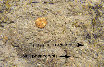 The rock is composed of rhyolite, but note that there are distinct phenocrysts seen. The pink ones are potassium feldspar while the light gray ones are plagioclase. Thus, we are looking at the obviously named Buzzard Rock member of the Mount Rogers Formation. For people who are interested in igneous petrology, here is some extra information. As you go up in the lava pile, the rocks become more silica-rich. The Buzzard Rock (the lowest) has the least silica and lacks quartz phenocrysts. The Wilburn Ridge (highest) has the highest silica and has quartz phenocrysts. This shows that the magma that fed the volcanoes "evolved" over time - changed in composition. The typical trend in magma evolution is toward increasing silica. As the magma sits underground, it partially crystallizes, with mostly feldspar crystals forming. Feldspar requires less silica, so that the remaining magma ends having a higher percentage of it. As magma is removed from below to feed the volcanoes above over time, the volcanoes become increasingly silica-rich. The rock is composed of rhyolite, but note that there are distinct phenocrysts seen. The pink ones are potassium feldspar while the light gray ones are plagioclase. Thus, we are looking at the obviously named Buzzard Rock member of the Mount Rogers Formation. For people who are interested in igneous petrology, here is some extra information. As you go up in the lava pile, the rocks become more silica-rich. The Buzzard Rock (the lowest) has the least silica and lacks quartz phenocrysts. The Wilburn Ridge (highest) has the highest silica and has quartz phenocrysts. This shows that the magma that fed the volcanoes "evolved" over time - changed in composition. The typical trend in magma evolution is toward increasing silica. As the magma sits underground, it partially crystallizes, with mostly feldspar crystals forming. Feldspar requires less silica, so that the remaining magma ends having a higher percentage of it. As magma is removed from below to feed the volcanoes above over time, the volcanoes become increasingly silica-rich. |
|
|
|
|
|
|
|
|
SPOT 4
|
|
|
|
 |
|
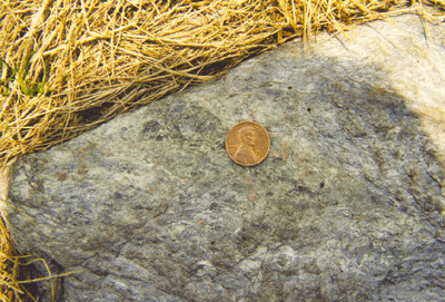
| Stream cobble in the lower Mount Rogers Formation from Stop 1. |
|
|
|
We have seen this rock before during the day. Remember the light colored coarse grained stream cobbles at Stop 1? We also saw this as dropstone material at stop 3. We saw this as material that makes up some of the larger clasts in the Konnarock Formation diamictite at stop 4. This is the Cranberry Gneiss! It is the 1 billion year old continental crustal basement rock that underlies most of the North American eastern seaboard. This is the same belt of stuff seen at other field trips during the Field School - the Little River Gneiss in Floyd County, and the Pedlar and Lovingston rocks of the Grand Virginia Tour between Roanoke and Lynchburg. This is a coarse grained "phaneritic" igneous rock. The main minerals in here are potassium feldspar (pink), plagioclase (cloudy white), and quartz (glassy gray). What rock is this? A granite! If you spend time and look at the ledges along here you will find that many of the rocks show a sheared, flattened out texture. This is typical of the Cranberry. Although it is originally a granite, due to the numerous shear zones and faults that cut through it, it commonly looks layered, thus the name Cranberry GNEISS. At this location, we are just above a large regional fault called the Stone Mountain Fault accounting for the shearing. |
|
|
|
|
|
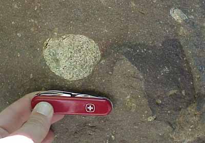
 Dropstone from the Konnarock Formation from Stop 3. Dropstone from the Konnarock Formation from Stop 3.
|
|
|
 Diamictite cobbles in the Konnarock Formation from Stop 4. Diamictite cobbles in the Konnarock Formation from Stop 4. |
|
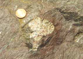
 Rock at the base of the Buzzard Rock member showing a coarse rubbly texture rom Stop 5. Rock at the base of the Buzzard Rock member showing a coarse rubbly texture rom Stop 5. |
|
| A couple of other things to note. We have crossed the contact between the Cranberry and the Buzzard Rock of the Upper Mount Rogers Formation. The contact is considered to be a "nonconformity". In other words, the Cranberry existed as an eroding land surface, then the rhyolite erupted on top of it. This accounts for the rubbly appearance of the rhyolite just above the contact. Not only are there sedimentary clasts included in the rhyolite, but pyroclastic pieces ejected during the rhyolite eruption are also included. Note that we are missing the lower part of the Mount Rogers here (the conglomerate). Keep in mind that the landscape 760 million years ago was quite rugged and you would only find the conglomerate in lower elevations like the stream valleys. This outcrop was apparently higher in elevation. The Cranberry served as source material for the sediment of the the overlying formations such as the Mount Rogers, the Konnarock, and even the Unicoi. It was eroded by streams and by glaciers. It is ironic that few of the cobbles and dropstones from the overlying formations show any of the shearing texture we see in Cranberry outcrops. This is to be expected. The cobbles and dropstones were eroded and deposited from the Cranberry in the late Proterozoic. The shearing didn't take place until much later in the Paleozoic as part of the Appalachian Mountain building. |
|
|
|
|
|
|
|
|
| At this point, you might be curious as to how the geology of the various stops all fits together in the geologic story. For that, refer to the Geologic History page. |
|
|
|
 |
 |
 |
 |
 |
|
|
|
|
|
|
|
|
|
|
|
|
|
|
|
|