|
|
|
|
|
|
 |
|
QUESTION 1
|
|
|
|
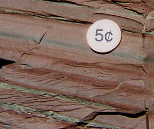 The maroon bands are composed of a mud, making this part of the rock a shale (or "argillite"). In order to deposit such fine sediment, we need to have very quiet water so that mud in suspension can settle out slowly. A quiet lake is a good possibility. An important tidbit of information for future reference is that all the sedimentary rocks found in the Konnarock Formation (and also the Mount Rogers Formation - but not the Unicoi) are considered to be land (as opposed to ocean) deposited. The reasons for this will be developed more as we go through the trip. But for now, we are not looking for an environment like "continental shelf" for this rock. The maroon bands are composed of a mud, making this part of the rock a shale (or "argillite"). In order to deposit such fine sediment, we need to have very quiet water so that mud in suspension can settle out slowly. A quiet lake is a good possibility. An important tidbit of information for future reference is that all the sedimentary rocks found in the Konnarock Formation (and also the Mount Rogers Formation - but not the Unicoi) are considered to be land (as opposed to ocean) deposited. The reasons for this will be developed more as we go through the trip. But for now, we are not looking for an environment like "continental shelf" for this rock. |
|
|
|
|
|
|
|
|
|
QUESTION 2
|
|
|
|
| The grain size is silty, and the material is composed more of quartz. To deposit this, we need to have a current that is slowing down so that the silt sized grains can drop out of suspension. This is consistent with the idea of a lake with streams feeding sediment into the lake. Alternatively, we can deposit the silt as turbidity currents (sediment+water currents) that flow along the lake bottom. |
|
|
|
|
|
|
|
|
QUESTION 3
|
|
|
|
|
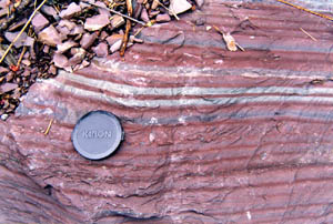 The current thinking on these rocks is that these are "varves". Varves form in lakes in cold climates. In the winter months, the lake freezes, the water becomes very quiet, and mud in suspension is allowed to settle. In the warmer months, we have a more active situation. Streams bring silt (and mud) to the lake, and the silt settles out. Thus, the type of sediment is seasonal, and each mud-silt pair represents a one year cycle. This is one of the few instances in geology where it is possible to physically count numbers of years in a rock. These monotonous cycles are called "rhythmites", for obvious reasons. The current thinking on these rocks is that these are "varves". Varves form in lakes in cold climates. In the winter months, the lake freezes, the water becomes very quiet, and mud in suspension is allowed to settle. In the warmer months, we have a more active situation. Streams bring silt (and mud) to the lake, and the silt settles out. Thus, the type of sediment is seasonal, and each mud-silt pair represents a one year cycle. This is one of the few instances in geology where it is possible to physically count numbers of years in a rock. These monotonous cycles are called "rhythmites", for obvious reasons. |
|
|
|
|
|
|
|
|
QUESTION 4
|
|
|
|
|
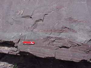 The sediment here is much coarser than at spot A. This is a sandstone. Keeping in mind that this is a lake, a way to bring sandstone into a lake is again by turbidity currents, although these were much larger and stronger than ones that could have formed the silt layers. Perhaps sand accumulating at the margins of the lake got kicked loose (maybe by an earthquake), and that sent the sediment-water current flowing into the center of the lake like an underwater landslide. The isolated chips of red mud near the base are "rip up clasts". The current that formed this was so abrasive that it literally scoured the previously deposited red mud, ripped it up, and incorporated the chips into the flow. The bottom of the sandy layer literally scoured grooves into the underlying varves. Amazing!! The sediment here is much coarser than at spot A. This is a sandstone. Keeping in mind that this is a lake, a way to bring sandstone into a lake is again by turbidity currents, although these were much larger and stronger than ones that could have formed the silt layers. Perhaps sand accumulating at the margins of the lake got kicked loose (maybe by an earthquake), and that sent the sediment-water current flowing into the center of the lake like an underwater landslide. The isolated chips of red mud near the base are "rip up clasts". The current that formed this was so abrasive that it literally scoured the previously deposited red mud, ripped it up, and incorporated the chips into the flow. The bottom of the sandy layer literally scoured grooves into the underlying varves. Amazing!! |
|
|
|
|
|
|
|
|
|
|
|
|
 |
|
|
 |
|
 |
 |
 |
|
 |
|
|
|
|
|
|
|
|
|
|
|
|
|
|
|
|
|
|
|
|