
Valley and Ridge Physiography: Regional Setting (Part 1)
• The Valley and Ridge extends from Alabama to New York state and beyond into Canada.
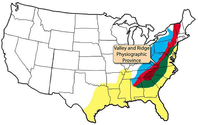
Location map showing the four major Appalachian physiographic provinces -- Piedmont (green), Blue Ridge (maroon), Valley and Ridge (red), and Appalachian Plateaus (blue)-- and the Coastal Plain (yellow). The Valley and Ridge extends from Alabama to New York state and into Canada. (Image by Phyllis Newbill. Base map couresy of the United States Geological Survey.)
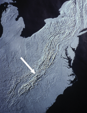 Map showing the physiography of eastern North America. Arrow shows the belt of parallel valleys and ridges commonly referred to as the Valley and Ridge physiographic province. Strictly speaking, the term Valley and Ridge is applied only to the part of the belt from Alabama to northern Pennsylvania. The northernmost section in the United States, called the Hudson River lowlands, is mostly soft shale and lacks the distinctive Valley and Ridge topography found in the central and southern Appalachians.
(Image courtesy of the United States Geological Survey)
Map showing the physiography of eastern North America. Arrow shows the belt of parallel valleys and ridges commonly referred to as the Valley and Ridge physiographic province. Strictly speaking, the term Valley and Ridge is applied only to the part of the belt from Alabama to northern Pennsylvania. The northernmost section in the United States, called the Hudson River lowlands, is mostly soft shale and lacks the distinctive Valley and Ridge topography found in the central and southern Appalachians.
(Image courtesy of the United States Geological Survey)
• In the southern and central Appalachians (Alabama to Pennsylvania), the Valley and Ridge lies between the Blue Ridge to the east and the Appalachian Plateaus to the west.
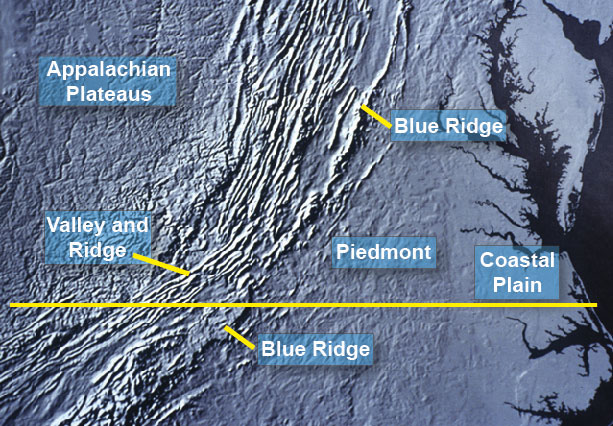
This physiographic map of the mid-Atlantic region shows the location of the Valley and Ridge between the Blue Ridge to the east and the Appalachian Plateaus to the west. The yellow line marks the approximate location of the southern border of Virginia. (Image courtesy of the United States Geological Survey)

Roanoke marks the break point between the central and southern Appalachians. Here the Valley and Ridge shows a sharp change in direction from about North 60 degrees East south of Roanoke to about North 30 degrees East north of Roanoke. The rocks are different also, being more deformed (with tighter folds and more thrust faults) in the southern Appalachians than in the central Appalachians. (Image courtesy of the United States Geological Survey)