
Mapping Geologic Structures (Part 1)
Geologic structures such as anticlines, synclines, domes, basins, and faults are not always easily visible. By mapping the slopes, orientations, and types of rocks in an area, geologists can create a geologic map and a geologic cross-section to learn about the structures.
2. Geologic maps and cross sections
Strike and Dip
• Strike and dip are measurements of the orientation and slope of a rock. Geologists use these measurements to map geologic structures.
• The dip of a rock is the angle between horizontal and the slope of the rock.
• The strike of a rock is the orientation of a horizontal line drawn perpendicular to the dip.
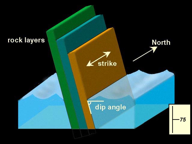
Strike and Dip ( Diagram by Phyllis Newbill)
In the diagram above, strike can be found easily on the rock layers because the surface of the water represents a horizontal plane. The strike is due North. The dip is the angle between the surface of the water and the rock surface. The dip is 75 degrees East. The map symbol for this strike and dip is shown in the inset.
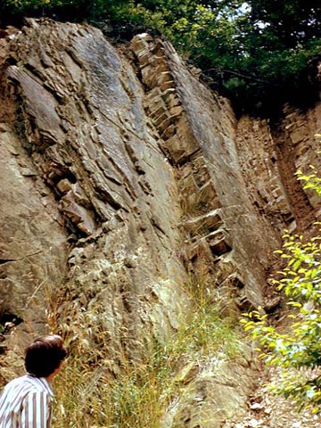
Dipping rock layers (Photograph by Stan Johnson)
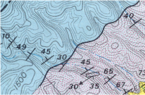
Map courtesy of the Division of Geology and Mineral Resources
Strike and dip are often easier to see on an exposure of rock than on a map, as the above photograph shows. Geologists use strike and dip symbols on geologic maps to show strikes and dips measured in the field. The geologic map (left) shows many strike and dip symbols.