
Introduction to Physiography, Part 2
• Virginia has five major physiographic (or geomorphic) provinces: Coastal Plain, Piedmont (includes Mesozoic Basins), Blue Ridge, Valley and Ridge, and Appalachian Plateaus.
• Each of Virginia’s five physiographic provinces has distinct features that are different from the features of other provinces.
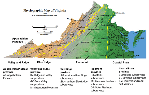
The Physiographic Provinces of Virginia. The yellow lines represent the province boundaries. Notice that the Blue Ridge is quite narrow north of Roanoke. (Map courtesy of C. Bailey)
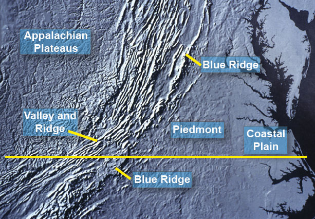
This physiographic map of the mid-Atlantic region shows the location of the Coastal Plain, Piedmont, Blue Ridge, Valley and Ridge, and Appalachian Plateaus. The yellow line marks the approximate location of the southern border of Virginia. (Image courtesy of the United States Geological Survey)
Short Summary of Virginia's Physiographic Provinces
Coastal Plain Physiography
• The easternmost province of Virginia is composed of flat landscapes and wide rivers that are easy to navigate.
• The port cities of Norfolk and Hampton are in the Coastal Plain.
• The western boundary of the Coastal Plain, where it borders the Piedmont, is called the "Fall Line". Here, the land gets noticeably steeper on the west side with rapids and rock outcrops common in river valleys.
• A number of Virginia cities are located along the Fall Line (Washington D.C., Fredericksburg, Richmond, and Petersburg). Interstate 95 connects these cities and follows the Fall Line.
Piedmont Physiography
• Piedmont means "foothills" and is composed of low, rolling hills, and is the largest of the physiographic provinces.
• The "Mesozoic Basins" are regions of broadly flatter topography that are included within the Piedmont.
• Charlottesville, Lynchburg and Martinsville are within the Piedmont Physiographic province. More discussion about Charlottesville and Lynchburg can be found here.
Blue Ridge Physiography
• The Blue Ridge contains the most rugged and highest land in Virginia.
• North of Roanoke, it is narrow and forms a distinct ridge of resistant rock.
• South of Roanoke, it forms a broad area of high ground ( or "upland"), with a steep slope (escarpment) on the east side.
• The Skyline Drive and Blue Ridge Parkway north of Roanoke follows the crest of the Blue Ridge, with spectacular views both to the east and west. South of Roanoke, the Parkway follows the edge of the escarpment, with great views mostly toward the east.
Valley and Ridge Physiography
• The Valley and Ridge consists of long ridges and valleys that parallel the northeast-southwest direction.
• I-81 follows the "Great Valley" which consists of: the Shenandoah Valley, the Roanoke Valley, and the New River Valley, and connects the cities of Winchester, Harrisonburg, Staunton, Radford, Wytheville, and Brsitol. The bedrock along the Great Valley is carbonate (limestone and dolostone).
• The Appalachian Trail follows hard sandstone ridges in the western part of the Valley and Ridge.
• It contains a distinct type of drainage pattern called "trellis" that consists of straight parallel streams that follow the less resistant limestone and shale valleys.
Appalachian Plateaus Physiography
• The Appalachian Plateaus is the westernmost province and it is composed of deeply cut valleys.
• The rocks have a horizontal orientation, and where there is tough resistant sandstone, the sandstone can form mountain caps that forms flat-topped plateau-like mountains.
• Because the rocks are not tilted, they do not control the path of the streams. As a result, the Appalachian Plateaus has a drainage pattern called "dendritic".
• In Virginia, all the streams and rivers that drain the Appalachian Plateaus flow north or west toward the Ohio and Mississippi Rivers.